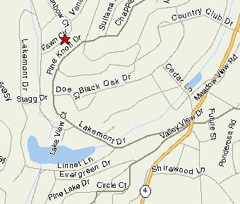
3426 Fawn Circle
Arnold, California
Lot 321
Altitude 4250 Feet
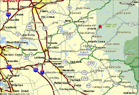
Driving directions from the San Francisco Bay Area
Trip time (from Palo Alto) approximately 150 miles (3 hours)
Take highway 580 East ( from San Francisco accessible via the Bay Bridge, from points South via 680 in San Jose or 238 from 880 in Hayward ).
Before Tracy, fork North onto Interstate 205 East which terminates onto 5 North in the central valley. Take the second exit (less than a mile) highway 120 about 10 miles until it turns onto highway 99 North. This first exit is Mantica a convenient and inexpensive gas stop for some miles.
Remaining on 99 North for about another 10 miles, exit on highway 4 East toward Farmington. Congratulations you have exited the cities.
In 46 miles you will have traveled over the first foothills and have entered Calaveras County and shortly the city of Angels Camp. At Highway 49 you may turn right entering the city of Angels Camp and its historic downtown or just stay on the highway 4 bypass. If you chose the Angels Camp exit look for highway 4 East again as a left turn toward Bear Valley and Ebbits pass at the end of the historic section.
In 23 miles of a fair bit of climb and when entering the city limits of Arnold, you will take the first left turn onto Lakemont Drive. You must stay on this road for approximately 1 mile, before the first right turn onto Fawn Circle. Staying onLakemont Drive is a little a bit tricky. When descending Lakemont Drive you must turn right at the bottom of the hill and then fork left following the lake on your left. As soon as you begin ascending again, continue streight until Fawn Circle on your right continues your ascent. Our house is the third driveway on the right.